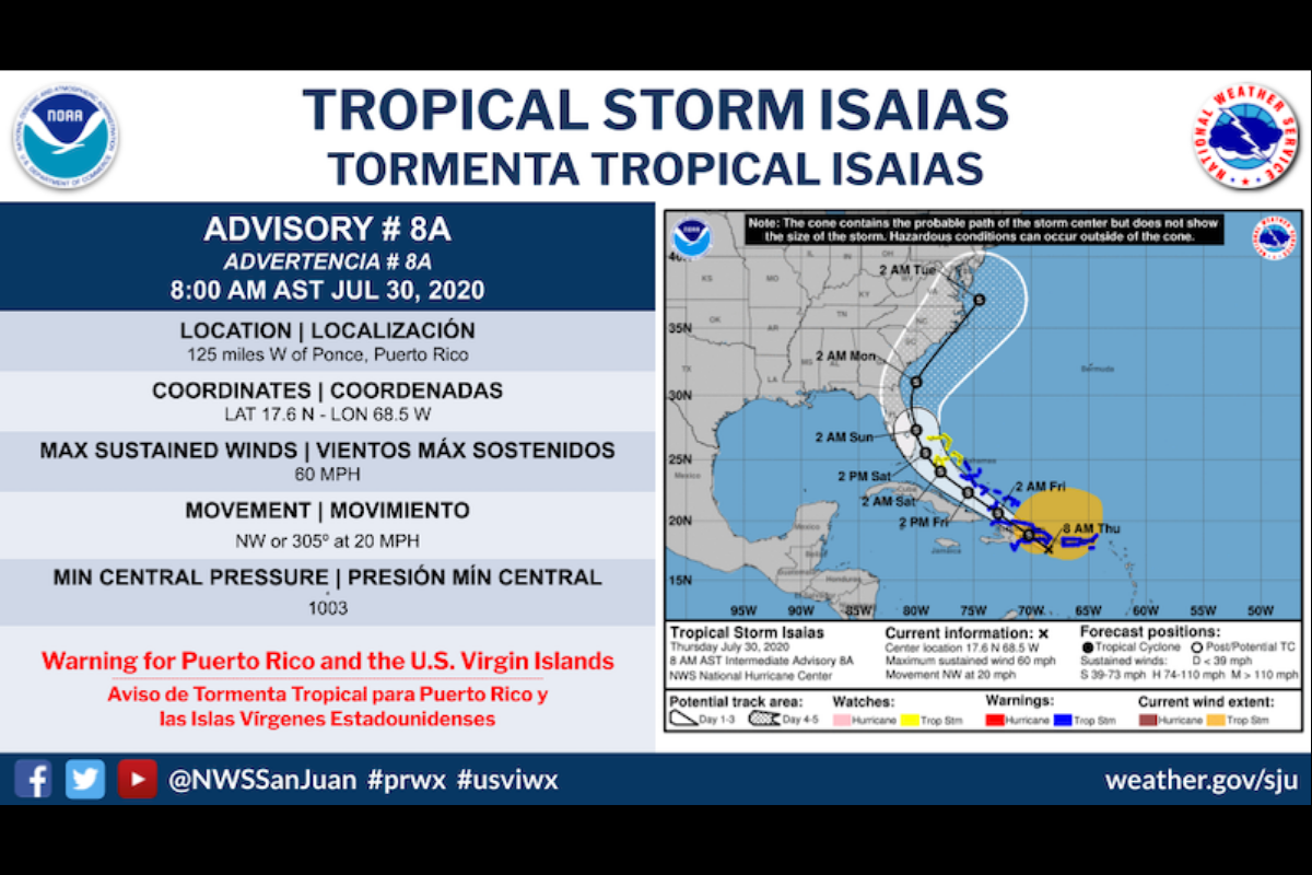

Via National Weather Service (Public Domain)
By DÁNICA COTO, Associated Press
SAN JUAN, Puerto Rico (AP) — Tropical Storm Isaias battered Puerto Rico on Thursday as it continued on a forecast track toward the U.S. mainland, unleashing small landslides and causing widespread flooding and power outages on an island still recovering from previous hurricanes and earthquakes.
Especially hard hit by the storm’s maximum sustained winds of 60 mph (95 kph) was Puerto Rico’s southern region, which is still being shaken by daily tremors. Santos Seda, mayor of the southwest town of Guánica, told The Associated Press that he has received reports of downed trees and inundated neighborhoods where earthquake-damaged homes still stand.
“The emotional state of people is deteriorating more every day,” he said, adding that crews will fan out to assess damage once the weather clears.
Isaias was centered about 125 miles (205 kilometers) west of Ponce, Puerto Rico, and about 105 miles (175 kilometers) east-southeast of Santo Domingo, Dominican Republic Thursday morning, according to the U.S. National Hurricane Center. It was moving west northwest at 20 mph (31 kph), and its center was expected to move over Hispaniola later on Thursday and near the southeastern Bahamas by early Friday.
How much rain has Tropical Storm Isaias dropped on Puerto Rico? Just weeks ago, the water level was so low that more than 100K clients received water only every other day. Today: https://t.co/MwqBgUbpZY
— Dánica Coto (@danicacoto) July 30, 2020
The storm knocked out power to more than 300,000 clients across Puerto Rico, according to the island’s Electric Power Authority. Minor damage was reported elsewhere in the island, where tens of thousands of people still use tarps as roofs over homes damaged by Hurricane Maria in September 2017.
José Pagán, a 22-year-old who lives in the eastern mountain town of Juncos, said his power went out before dawn.
“I didn’t think it was going to be this strong,” he said of the storm, adding that his home is slightly flooded. “It’s a rather difficult experience because it reminds us of Maria.”
The hurricane center said Isaias, for now, is not expected to become a hurricane before reaching the U.S. mainland.
“Isaias is sending some mixed signals,” the forecast discussion stated. “Model forecasts are showing a complex evolution of the tropical cyclone during the next day or two.”
Tropical storm warnings were issued for Puerto Rico, the U.S. and British Virgin Islands, the Turks and Caicos Islands and portions of the Dominican Republic, Haiti and the Bahamas.
Isaias was expected to produce 3 to 6 inches (7 to 17 centimeters) of rain across the British and U.S. Virgin Islands and Turks and Caicos and also across Puerto Rico, northern Haiti, and eastern Cuba with isolated maximum totals of 8 inches (20 centimeters).
The Dominican Republic and the Bahamas could see 4 to 8 inches (10 to 20 centimeters) of rain while Cuba could see 2 to 4 inches (5 to 10 centimeters), with isolated maximum totals of 6 inches (15 centimeters).
Isaias is the earliest ninth Atlantic named storm to form, according to Colorado State University hurricane researcher Phil Klotzbach. The previous record was Irene on August 7, 2005, Klotzbach tweeted.
National #Hurricane Center gives 90% chance of tropical cyclone formation in next 5 days for disturbance currently in the eastern Atlantic. If it forms, it would be named #Isaias. Current record for earliest 'I' storm in the Atlantic basin is Irene on August 7, 2005. pic.twitter.com/8cM256suT5
— Philip Klotzbach (@philklotzbach) July 26, 2020
So far this year, Cristobal, Danielle, Edouard, Fay, Gert and Hanna have also been the earliest named Atlantic storms for their alphabetic order.


