
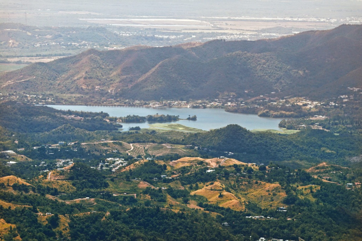
The Cordillera Central, the Toa Vaca reservoir, and the southern coast of Puerto Rico, seen from the Mirador Villalba-Orocovis. (Edgar Freytes/Centro de Periodismo Investigativo)
By ELIVÁN MARTÍNEZ MERCADO, CPI
SAN JUAN — Photographer Edgar Freytes arrived at the Mirador Villalba-Orocovis, a key stop on the Panoramic Route, which zigzags through the mountains of Puerto Rico from end to end. But a sign attached to the gate brought him down: “Closed until further notice. Do not enter.”
The place enjoys a privileged view of the Central Mountain Range, the Toa Vaca reservoir, and the Caribbean Sea, to the South, and the Atlantic, to the North.
“Sometimes you make long trips just to find out that these places are closed, and you waste your time. They leave us with nothing and force us to go to other places where we must pay. This is outdoors and you don’t have to pay,” he said.
Yonelis Caraballo, who had come from Coamo with another group of friends “to enjoy nature,” was also surprised by the closing. “It’s disappointing,” she said. “It would be nice if there was information about the closure, because that way, we don’t make the trip.” Although the location stopped operating after Hurricane María, the Discover Puerto Rico website, which promotes tourism on the island, states that the Mirador Villalba-Orocovis vantage point is open.
It says it is a “strategically located park, overlooking the south-central mountain range, perfect for a picnic or visiting one of the local businesses along the route.” A minute’s walk away, the Villa Oro Restaurant put up a “For Sale” sign over the business entrance. Edith Aponte, one of the owners, says that the closure of the vantage point has caused a drop in visitors, one of the factors that has forced her business to throw in the towel.
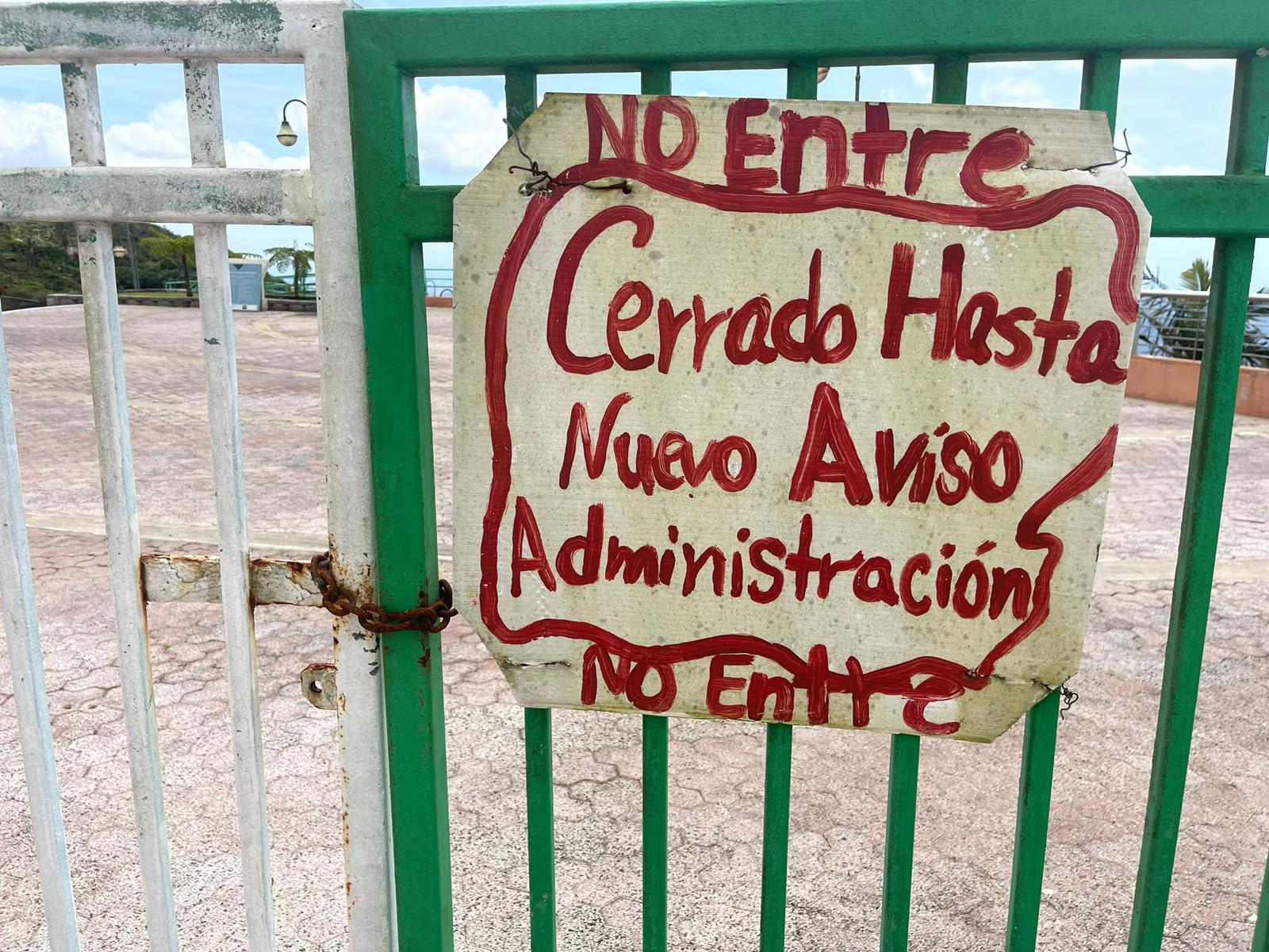
The Mirador Villalba-Orocovis has been closed since hurricane María hit the Island in September 2017. (Centro de Periodismo Investigativo)
The Center for Investigative Journalism (CPI, in Spanish) found that the route is lifeless. In addition to the closure of the Mirador Villalba-Orocovis, the observation tower at Piedra Degetau, in Aibonito, is also closed, and the one at Cerro Maravilla, near the Ponce-Jayuya municipal limit, is abandoned. These are the three most important viewpoints of the Panoramic Route.
The fresh air taken in by those who visit by car or on foot, the dips in the bodies of water that run near the highways, the silence accompanied by the song of the birds, are all coupled with the serious deterioration of the public infrastructure along the route. The main parties responsible for maintaining the spaces are the Highways and Transportation Authority (ACT, in Spanish), the Department of Transportation and Public Works (DTOP), the Department of Natural and Environmental Resources (DRNA) and municipalities such as Aibonito and Villalba.
To carry out the public policy of preserving and developing the Panoramic Route, the ACT commissioned a new Management Plan in 2016, which has been ready since 2021 but has not yet been implemented, the ACT’s Executive Director Edwin González admitted. The plan, which updates the original one from 1998, includes seven interpretive regions and the development of new observation points. It is not a text on road infrastructure but on the strategic development of the Panoramic Route surroundings. It’s about the entire offer that extends up to a mile on each side of the Route, including hotels, restaurants, and historical, archaeological, cultural, and scenic centers, among others.
“The main challenge is the funds. There are no funds,” González confirmed to the CPI. The agency has just begun the planning and design process for this new stage of the Panoramic Route and is hiring experts and managers to implement the plan. These contracts will be paid with the agency’s own funds, but there are still additional allocations for repairs or construction of projects.
Carlos Fernández, coordinator of ACT Planning Programs, said that, in addition to the natural disasters and earthquakes that have affected the agency’s projects, his office is understaffed: it has only three out of 18 people. This is a consequence of the ACT’s incentivized retirement windows during the administrations of former governors Luis Fortuño, Alejandro García Padilla and Ricardo Rosselló, who sought to reduce the government workforce, according to the agency.
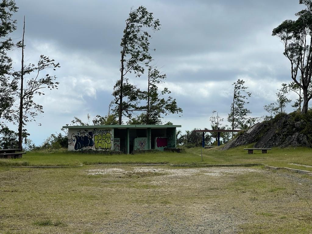
The observation point at Cerro Maravilla is abandoned and covered in graffiti. (Centro de Periodismo Investigativo)
Besides, there is the slow reconstruction process post-Hurricane María, which hit in 2017. There is at least $3.6 million for seven projects to be funded by the Federal Emergency Management Agency (FEMA) for permanent work, destined for lookout points, recreational centers and forests located along the Panoramic Route, which the DRNA and the municipalities of Aibonito and Villalba administer. Five years after the natural disaster, only one project has partially started, the CPI found.
“There’s neglect. Look how the roads are. In disrepair,” said Teresita Cintrón, organizer of the Caminata Panorámica Arquitecto Gabriel Ferrer, the 150-mile pilgrimage between Yabucoa, to the southeast, and Mayagüez, to the West. It was founded by the defunct Fondo de Mejoramiento, a nonprofit entity that promoted human development, environmental conservation, and internal tourism. Cintrón speaks with the knowledge of someone who has been walking this route for 37 years.
This year was the first time when walking parts of the route were canceled due to the poor condition of the road infrastructure, she said. The deep craters in the pavement symbolize an abandoned geography. In different sections there are no guardrails, there are landslides, and at one point on Highway 339, on the way to Mayagüez, some cement fences completely block the way, so you must make a detour.
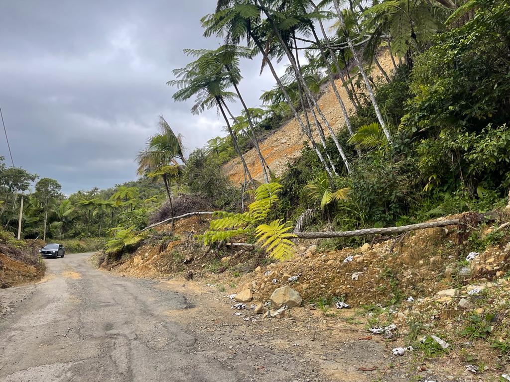
Route 143, km 16, part of the Panoramic Route, is partially blocked by a landslide. (Centro de Periodismo Investigativo)
According to a survey carried out to prepare the new Management Plan, 88 percent of those interviewed said the Routes’ biggest deficiency is the poor conditions of the road. A company called CSA carried out the survey, randomly interviewing 35 people who were in town squares, parks, chinchorros (rustic bars and restaurants) and museums, during field visits to the Panoramic Route and its surroundings, in 2019.
If the main tourist offer in Puerto Rico is the beaches, the Panoramic Route is its counterpoint. It’s the island’s longest green infrastructure corridor. Brushed with agricultural sceneries and the everyday life of inland towns, it crosses the Carite, Toro Negro, Guilarte and Maricao forests. It runs through the areas of the highest peaks such as Cerro Punta (4,390 feet above sea level), Monte Jayuya (4,301 feet) and Cerro Maravilla (3,973 feet).
“One can appreciate all of Puerto Rico’s beauty,” said Vivian Estrella, a native of Guaynabo, who was participating in the Panoramic Walk for the first time, as a warm-up to do the Camino de Santiago later in Spain.
Along the way, visitors may stop at restaurants and small eateries. Migdalia Bernier, from Cayey, was delighted with the “cordiality of the people” who waved to her as she walked. “We ate limbers (local popsicles) and bread pudding and had lemonade from a lady who made a lot in a bowl,” Bernier said.
It is not only an option for tourists, but to bring economic activity that results in a source of income for mountain residents. All the municipalities along the Route, except for Cayey, have higher levels of poverty than the rest of Puerto Rico.
Without Signs, You Don’t Know Where the Road Goes
The 165 miles of the Panoramic Route can be completed in three or four days by car, with enough time to stop at the main points of interest, depending on one’s pace. Whoever wants to walk it in a single shot can take about 14 days, as the Fondo de Mejoramiento did in its beginnings. It is usually done from east to west, to travel with the sun behind you instead of facing it.
Leaving from the eastern coast of Yabucoa, on Highway 901, the coastal part of the route begins at Playa Lucía. The island of Vieques is visible in the distance and, further on the road, Punta Tuna Beach appears with its lighthouse. In Maunabo there’s a road circuit that reconnects with Yabucoa. The agricultural plains that were once dedicated to sugarcane can be appreciated from above.
Before entering Maunabo, when leaving PR-901, at an intersection, the serious problem of the lack of signs is revealed. Because there are no signs, it’s hard to tell where the Route continues. The driver is easily disoriented along some 40 roads in the 21 municipalities that it spans. The Management Plan, which has not yet been made public and which the CPI obtained through a request for information, confirms these observations: “the inconsistency in the traffic signs identifying the Route confuses rather than informs travelers.”
And you cannot trust the mobile phone’s GPS because there are mountainous areas where the signal is lost. It is a good idea to carry a printed road map, the old-fashioned way. In some areas, the attentive driver or walker will orient themselves thanks to white dots painted on the asphalt at some intersections, a signaling service implemented by the Fondo de Mejoramiento.
To the west, the mountains of Cayey, PR-15 offers in summer the spectacle of hundreds of blooming oaks, in a 254-acre farm that belongs to the Conservation Trust of Puerto Rico. The road continues to ascend, offering views of the Guayama coast, and leading to the beginning of the panoramic segment from Aibonito to Maricao, where the main vantage points are located.
Discover Puerto Rico also promotes the Mirador de la Piedra Degetau, in Aibonito, on its website. But visitors come to find that a wooden pallet blocks access to the observation tower stairs. The facilities, built in 1996 with federal and ACT funds, were transferred to the municipality in 2010 through a lease agreement, to prevent its deterioration. The administration subleased it in 2015 to La Piedra Degetau LLC, to manage it, and then Hurricane María caused damage to the tower. The municipality told the CPI that it was not up to the private company to repair it. In 2019, Aibonito subleased the recreational area to a new company, Degetau Restaurants LLC, which set up a pizzeria there.
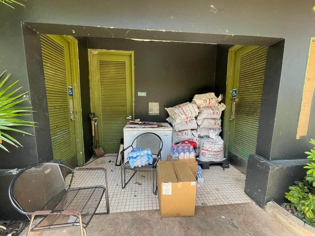
This is how the Mirador de la Piedra Degetau’s bathroom entrance looks. (Centro de Periodismo Investigativo)
The allocation of $354,287 in FEMA funds to rebuild the facility came in February 2020. The town decided to close access to the tower because the structure was affected and estimated damage to the entire area at $500,000.
“Only access to the Tower was closed at the end of 2021. The rest of the Mirador facilities continue to be open and functional,” according to statements sent by the Municipality of Aibonito. But, except for the area where the pizzeria is located, the recreation center gives the impression of neglect.
During the CPI’s visit, there was trash in the surroundings, the water fountains were not working, and the gazebos were filled with debris. The bathroom doors were closed, and the entrance was used as a storeroom for the restaurant.
Three years after the FEMA funds allocation, the reconstruction of the Mirador de la Piedra Degetau is still in the design phase, the Municipality confirmed. It alleges that it is putting together a “master plan” to improve it and turn it into a “larger scale” tourism project.
Some cars drive into one of the parking spaces of the closed Mirador Villalba-Orocovis because the dilapidated gate is off its rail. Binoculars, which work with coins, are out of service. The facility was built with funds from the federal and local governments and inaugurated in 2002. Now it is operated by the Municipality of Villalba, which closed it after María because the hurricane caused damage to the structure, lighting, and surroundings, according to the local authorities.
Although FEMA obligated $121,375 three years ago, nothing has happened with the project yet. The Villalba administration told the CPI that it is waiting for other funds from the Puerto Rico Tourism Company to do the work with municipal brigades. They attribute the delay to inflation, which has made construction materials more expensive, and the lack of manpower.
Zigzagging to the west, you come to the Bosque de Toro Negro recreational area, where the water murmurs as it hits the rocks, next to one of the main paths. Those who follow this path can dip their feet or plunge into the cold water. After climbing the rocks, travelers come across a chain and a padlock on the gates of what used to be a natural water pool, one of the attractions of the area, which has been out of service for more than 20 years. Due to problems with leaks, it is presently full of mud and weeds.
In the parking lot, kiosks and restrooms are closed. Although the forest should open every day, according to the schedule published by Discover Puerto Rico, it is normal to find the main gate and the tourist information office closed from Monday to Friday.
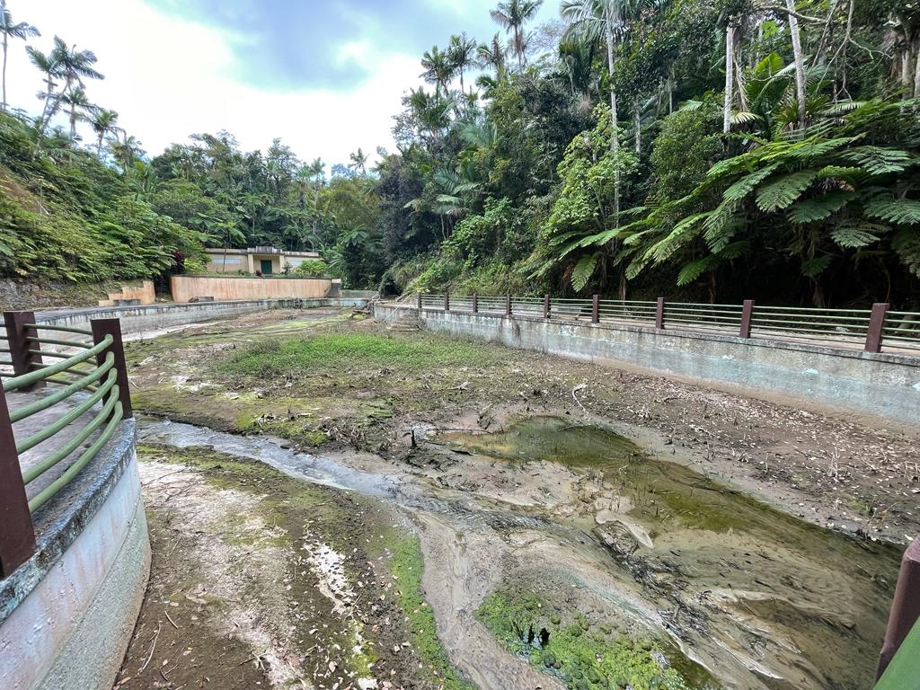
At the Bosque Toro Negro, the natural water pool has been out of service for more than 20 years. (Centro de Periodismo Investigativo)
The DRNA has a co-management agreement with nonprofit organization Amigos del Bosque Toro Negro. Carmen Enid Báez Vitali, its president, said she does not have volunteers to keep the facilities open during the week.
The DRNA is the agency in charge of protecting, managing, and making Puerto Rican forests available to the public.
“That is shocking. The local tourist finds it difficult to know the schedule. The Natural Resources (DRNA) page is unreliable. It doesn’t provide that information. You call and it goes to an answering machine. You go from one extension to another, and no one answers the phone,” said José “Pepe” Collazo, who coordinates a group called the Alegres Caminantes, made up mainly of retirees who enjoy “first-hand the beauties of Puerto Rico.” He considers himself a “son of the Panorámica” since he has been walking it since the 80s.
Between 2021 and 2022, the DRNA received FEMA funding obligations amounting to $1,823,167 to restore areas in Toro Negro, Carite, Maricao, Monte Guilarte and the Monte del Estado Vacation Center, public spaces along the Route. It was not until April 2023 that the Capital Improvements Program Management (CIPM), run by engineer Carlos Pesquera, was hired for $6.1 million to coordinate the agency’s reconstruction projects with FEMA funds. Pesquera said he is qualifying 27 firms to create designs and job instructions.
The swimming pools in the Monte del Estado Vacation Center are closed. (Centro de Periodismo Investigativo)
The agency did not respond to the question of when it expects to complete the reconstruction work, nor why it went almost two years without taking any steps for that.
Only partial work has been done in the Monte Guilarte State Forest, in which wooden walls and a galvanized roof were replaced in the cabins and the campfire site, according to the Central Office of Recovery, Reconstruction and Resiliency. In addition to these natural parks and recreational spaces, there are DRNA facilities in the vicinity of the Panoramic Route, which are also on the reconstruction schedule. FEMA allocated $6 million in February to rehabilitate the Vivero de Peces de Maricao, one of the main attractions for visitors.
Further east, on the border that divides Ponce and Jayuya, rises the Cerro Maravilla. In the collective memory, it is the place where the Police ambushed and killed young pro-independence activists Carlos Soto Arriví and Arnaldo Darío Rosado in 1978. In the same decade, the DTOP built the namesake vantage point to the South of PR-143, on the Ponce side, as one of the founding projects of the Panoramic Route. Below, in the distance towards the South, are the city of Ponce, the Cerrillos reservoir, the island of Caja de Muertos and even the windmills that generate electricity on the agricultural plains on the coast of Santa Isabel.
Félix González, who offers therapies as a neurocoach, installed a wooden bench to enjoy the view. He then began to meet people there who felt depressed after the outbreak of the COVID-19 pandemic and decided to start a mental health movement in connection with nature. He activated volunteers who mowed grass, reforested, cleaned benches, revamped a gazebo, and created a public art project on the walls of the abandoned bathroom.
One day they found that someone had covered his artwork with paint, and that the wood and toilets he had brought to install there were missing. González said the DRNA’s legal division explained to him that an agency employee was responsible and asked the volunteers to start again with a clean slate. They became discouraged and abandoned community work.
Today, the traveler finds that the grass has taken over the land, due to lack of maintenance. The bathrooms have no doors or toilets, and the walls are covered in graffiti. The benches and gazebos need maintenance. The management plan indicates that the facilities are in a “dilapidated condition.” The ACT said the local Department of Agriculture owns the facility.
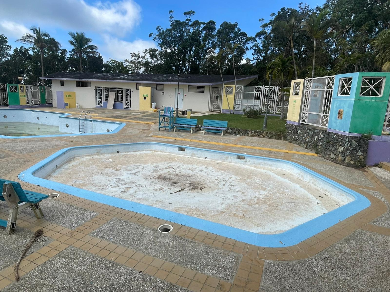
Some of the most popular attractions are along the border of San Germán and Maricao, such as the famous Monte del Estado Vacation Center. There are 22 cabins each with the capacity to accommodate up to six people, a swimming pool, basketball court and recreational area. At least that’s how it was in better times.
Today the paint on the gazebos is peeling; the swimming pools are closed and empty. During the CPI’s visit, the sink in one of the bathrooms did not work and in another, there was a constant drip. It’s a massive test of patience for the tourist who tries to visit, since no one answers the telephone numbers the DRNA publishes to make reservations. The nearby Ecological Park, one of the best camping areas in Puerto Rico, is closed.
Further down the Panorámic Route, visitors climb 44 steps to the Torre de Piedra observatory, and are rewarded by the 360-degree view that the Puerto Rican hawk, the guaraguao, sees. You can see the north coast of the island, the Caribbean waters in the south and the contours of the southwest coast.
The Torre de Piedra is within the Maricao Forest, a protected area of almost 11,000 acres of land. “I have my heart set on Maricao. For me it’s very valuable for Puerto Rico. We must give it its value,” said Teresita Cintrón, the organizer of the group Caminata Panorámica Arquitecto Gabriel Ferrer.
The day the CPI found her walking, her group had to call the DRNA and put pressure on the government to address the crisis of the forest fires, since fires had occurred in the area while they were visiting, she said. She has been meeting European and American scholars for years who come to study the flora and fauna, especially the birds, which she considers a recognition of the value of the area.
Act 71 of June 23, 1965, created the public policy to develop the Panoramic Route, to offer an ecological and social balance in the face of industrial development on the coasts. “This route will also be an excellent opportunity for our youth to learn about and study the flora, history and orography of our Island…,” according to the Act’s introductory statement. “It will serve to promote tourism for regular people, both from Puerto Rico and abroad, who wish to enjoy the typical Puerto Rican atmosphere at a moderate price; to this end, inns, picnic areas, gazebos, places to rest, and all the necessary enjoyment and recreation facilities will be built.”